This website needs some more activity, and as we are step by step publishing and publicizing outputs from the MIDLAND project, it seems time to kick-off this blog section.
In a first series of blogs, we will compile info on key outputs of the project already published, and which were synthesized on Twitter.
So, let’s start with our work on mapping smallscale and large-scale cropland by remote sensing in a test study area in Mozambique, serving our aims to make progresses toward improved understanding on land use change and deforestation, food security, land acquisitions…
This blog post builds on Bey et al. (2020) https://doi.org/10.1016/j.rse.2019.111611
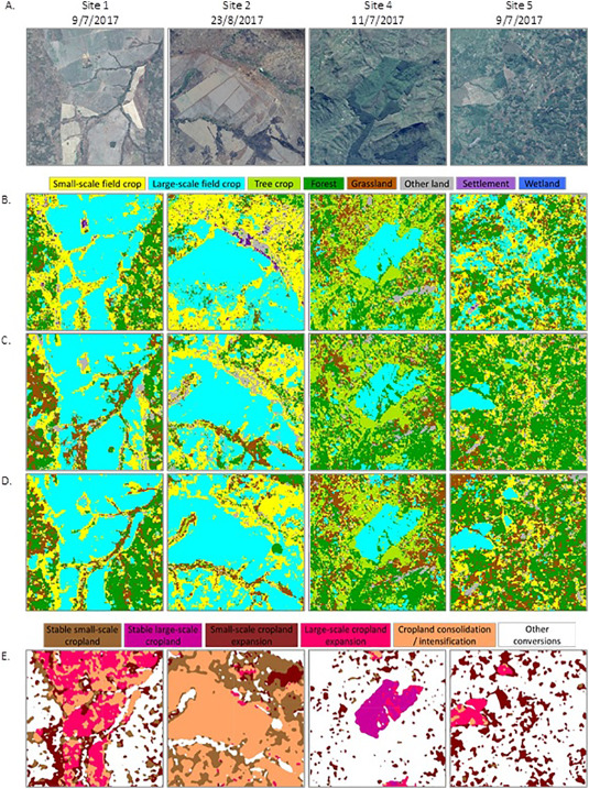
In that study, we focused on Gurué District (5606 km2) of Zambezia province of Mozambique, one of many countries in the region that has experienced a recent growth in foreign investments in agriculture through large-scale land acquisitions.
We built on open remote sensing data and tools including Collect Earth software and Google Earth Engine. We explored different compositing techniques, to show that median compositing performed best for disaggregating cropland by field size. Drawing upon Landsat data and using spectral and textural features, we characterized land use change over three time periods, 2006, 2012 and 2016, focusing on changes between small-scale cropland, large-scale mechanized cropland, and other land uses.
We showed that over 2007-2017, the largest source of change was small-scale cropland expansion. The gross area of small-scale cropland expansion (1214 km2) is approximately double the area of stable small-scale cropland (660 km2), and much larger than the large-scale cropland expansion that reached ~58 km2.
This method can be upscaled and applied in many parts of Africa with similar historic image availability challenges, and similar economic contexts with great disparities between small-scale unmechanized cropland and very large-scale mechanized cropland, to explore land consolidation dynamics and agent-specific pathways of land use change.